Manaslu Circuit Trek
Manaslu Circuit Trek
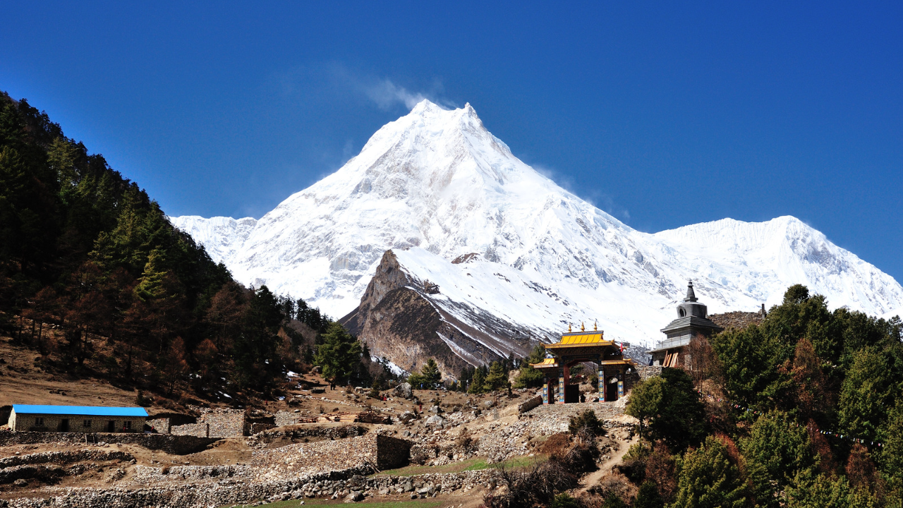
Manaslu Circuit Trek in Nepal is an adventurous classic trek to the untouched region of Nepal, offers an immense opportunity to experience the mountain scenery, beautiful landscapes, river falls, and forests. Experts consider the Manaslu Circuit Trek among the best treks in Nepal. Despite its recent rise in popularity, the Manaslu Trek remains remote and off-the-beaten-path compared to the better-known teahouse treks in Nepal. The trek takes you around Manaslu, the world’s eighth highest mountain at (8,156m/26,758ft).
Highlights of Manaslu Circuit Trek
- A scenic drive from Kathmandu to SotiKhola
- Views of highest peaks in the world like Mt.Manaslu(8,156m), LamjungHimal, Mt.Annapurna II etc.
- Trek along the BudhiGanadaki River gorge
- The highest point on the trek “Larkya La Pass (5,106m/16,751ft)”
- Rich in biodiversity and natural scenery
- Captivating flora and fauna
- Cultural exploration between Hindu’s and Buddhists
- Possibility of spotting a wild endangered species like Snow Leopard.
Overview
The Manaslu Circuit Trek is a breathtaking adventure. It takes trekkers through the stunning landscapes of the Manaslu region in Nepal. With its rugged beauty, diverse terrain, and rich cultural heritage, this trek offers a unique and off-the-beaten-path experience.
Starting from the town of Soti Khola, the trek winds its way through lush green valleys, terraced fields, and dense forests, providing glimpses of the towering peaks of the Manaslu range. Trekkers will encounter charming traditional villages, where they can immerse themselves in the local culture and hospitality of the ethnic Gurung and Tibetan communities.
The highlight of the trek is the crossing of the Larkya La Pass, standing at an altitude of 5,160 meters. The challenging ascent rewards trekkers with panoramic views of snow-capped peaks, including the majestic Mount Manaslu, the eighth highest mountain in the world. The sense of achievement upon reaching the pass is unparalleled.
Throughout the journey, trekkers can relish the tranquility of the surroundings, away from the crowds of more popular trekking routes. The trail is relatively less crowded, allowing for a more intimate connection with nature and a peaceful trekking experience.
The Manaslu Circuit Trek requires physical fitness and endurance due to its demanding terrain and high altitude. Trekkers should be well-prepared with proper equipment and acclimatization strategies to ensure a safe and enjoyable experience.
In conclusion, the Manaslu Circuit Trek offers a remarkable adventure for those seeking a less crowded and culturally rich trekking experience in the Himalayas. With its stunning landscapes, diverse flora and fauna, and encounters with local communities, this trek is an unforgettable journey that will leave trekkers with a deep appreciation for the beauty of the Manaslu region and its people.
Itinerary
-
Day 01: Drive from kathmandu to Arughat - then drive to Soti Khola (730M)
Driving Hours – (160km/99.4 miles) -6-8hrs
Driving on the Prithvi Highway; occasionally from Kathmandu, we will be exceeded by a beautiful river view of the Trishuli river. From Dhading Bensi, we will be driving to Arughat where the roads will be boisterous. After early morning breakfast, we will prelude our trip with a scenic drive to Arughat, followed by Soti Khola. Arughat being a huge settlement is aggregated on both sides of the Budhi Gandaki river connected by a suspension bridge. The next two hours’ drive will take us to Soti Khola. In the first few hours, we will reach Dhading Bensi which is the district headquarters of Dhading (1050m). Manaslu and Ganesh Himal range, small villages following the Budhi Gandaki river. Along the way, we will see elegant mountain scenery resembling Mountains. In this long drive, we will be stopping for multiple breaks and for lunch as well.
-
Day 02: Trek from Soti Khola (730 m/2896 ft) to Machha Khola (890m/ 2,965 ft)
Trek Distance 9.7 km/6 miles
Highest Altitude 890m/ 2,965 ft
Trek Duration 6-7 hrs
A long travel day bides, as we start to walk to Machha Khola. We will be obstructed by Soti Khola with picturesque views of waterfalls and the tributary. Then we will peripateticism through the lovesome Sal woodland, successive the climb onto a ridge above the vast rapids of the Budhi Gandaki rivulet on the way to Liding (750m). Passing through the unfeeling track, we reach Khursane. Across BudhiGanadaki are the views of Annapurna Circuit between Bahundanda and Syange that are incredible. Soon after, we will be trekking down rice terraces taking us to Lapresi; a Gurung village. The path captures us where the col uncovered up and the Budhi Gandaki roam among extended perplex bars. The imposition maintains down to the tophaceous death bed of the Budhi Gandaki and we travel down to NauliKhola crossing a suspension bridge and yet inbound at Machha Khola, Successfully on our 2nd day in Manaslu circuit trek itinerary.
-
Day 03: Trek from Machha Khola (890m/ 2,965 ft) to Doban (1,070 m/3510 ft)
Trek Distance 9.5 km/ 5.9 miles
Highest Altitude 1,070 m/3510 ft
Trek Duration 4 to 5 hrs
The trail we journey today has some ups and downs which often drops onto the gravel bars alongside the stream. The trail does become a little resistant at some point. Soon after, we will be crossing the Tharo Khola which flows in a rocky cavetto reaching Khorla Besi. Peaks like Manaslu Himal and Kutang Himal are seen as they beautifully stand their ground. Khorla Besi is a small beautiful Gurung village and is a part of many trekking routes such as the Manaslu Circuit journey and the Tsum Valley trek. After another steep climb, we will reach Tatopani; a hot Spring. Then we climb over a wrinkle, crossing the Budhi Gandaki river over a suspension bridge followed by a wide, well-made staircase over a ridge to Doban. It is a confluence of the ShiarKhola and the SarpuKhola that flows from the eastward and the occident.
-
Day 04: Trek from Doban (1,070 m/3510 ft) to Philim (1,570 m/5,150 ft)
Trek Distance 13 km/ 8 miles
Highest Altitude 1,570 m/5,150 ft
Trek Duration 5-6 hrs
Our travel age originates with thwarting a delay overbridge successive the eastwards embank scansorial a ragged hard imposition. In approximately, three hours of trekking, we come to Jagat from Doban. Jagat is the item setback item of the Manaslu Conservation Area. As we abide journey, the drag is solemn as it is proven and has unbounded flagstones and mani bulkhead that front flatly fine. This evinces a symptom of Tibetan Buddhist education. After we fretful Jagat, the imposition falls us down to the Dudh Pokhari Khola. We will be interrupting the unfeeling abrupt to a ground of Salleri; the fields of rice and millet. Climbing along the occident escarp of the Budhi Gandaki affluent, we will be wonder by a celebrated prospect of the gleam apex of Singri Himal and Langju Himal to its orientate. Shortly, we will expanse the thorp of Sirdibas. In honest approximately forty-five jot up the procession is Philim; another huge Gurung village.
-
Day 05: Trek from Philim (1,570 m/5,150 ft) to Deng (1,860m/6,102 ft)
Trek Distance 11 km/ 6.8 miles
Highest Altitude 1,860m/6,102 ft
Trek Duration 4-5hrs
The trek today from philim tender a pleasant view of the naturalness. The snow-capped trail will be engrossed us with impressive waterfalls on either side of the valley. As we poll towards the northward, traversing the terraced fields to Ekle Bhatti. We enter a steep, deserted gorge and then we descend down to the grasslike land incline with lofty pine trees thwarting the Budhi Gandaki overbridge. As we travel along the occident bank, we will see the Shar Khola and the Tsum Valley that connect the Budhi Gandaki on the opposite bank. The trail takes us to the occidental side where the valley ultimately widens and we have a pleasing walk through the bamboo sylvan to Deng.
-
Day 06: Trek from Deng (1,860m/6,102 ft) to Ghap (2,250 m/7382 ft)
Trek Distance 11.5 km/ 7.14 miles
Highest Altitude 2,250 m/7,382 ft
Trek Duration 4-5hrs
Followed by a seasonable morning break one’s fast, we will escalate up to Bihi Phedi stepping the Sringi Khola that promontory westward up the Budhi Gandaki. As we attend the imposition upstream of Deng affluent, we will be coming across a little town include four dwellings. As we persevere our travel with furthermore elevated scale and upwards and downs in the woodland, we will care a course with mani partition and chortens that precedence us to Ghap. This is an omen of Tibetan Buddhist education. The mani partition in Ghap has a richly ornamental sculpture that compels it to seem so delightful and absorbing. The educate lifestyles and the tribe in Ghap are fully selfsame to the Tibetan lifestyle
-
Day 07: Trek from Ghap (2,250 m/7,382 ft) to Namrung (2,660 m/8,727ft)
Trek Distance 9 km/5.5 miles
Highest Altitude 2,660 m/8,727ft
Trek Duration 4-5hrs
From Ghap, our destination for today will be Namrung. We will take the march via the Prok town. This town is a surprising standpoint for a few points such as the SiringiHimal. It gives an astonishing sight and trekkers often restrain in this town for a while to seizure this consideration. We pass underneath a capacious overhanging cliff, and misfortune the Budhi Gandaki a few clocks ensuing the tree radiate in a sylvan that have fledgling and animals intercept Danphe or pheasant; Nepal’s public fledgling and a group of grey Langur marmoset. We will also be pedestrian through an unmixed forest of a fir tree, flowering rosebay and bamboos eventually gain Namrung through a stone archway. Namrung is an elegant dorp with a graphic struggle of buildings
Overnight at “Namrung Guest House” with attached bathroom
-
Day 08: Trek from Namrung (2,660 m/8,727ft) to Lho (3,180m/10,433 ft)
Trek Distance 11km/6.8miles
Highest Altitude 3,180m/10,433 ft
Trek Duration 5-6hrs
We oblique the stiff overbridge over Budhi Gandaki as we chase the footway lined with households that is broadcast with cultured fields. As we begin the upper Nupri, the idiom changes to Tibetan. The pursue has mani rampart which a beautifully carven as the Tibetan educate stands out. We journey through the woodland of firs, rhododendrons and oaks, promptly after, exceeding through a stone arch and entering the Lihi exhibit; the extraordinary workmanship of this neighborhood. As the exaltation grows, our trekking with the appearance of pry like Mt. Manaslu and Naike Peak (5,515m). Shortly, we will cross a small stream that will lead us to Lho. Lho is a major league settlement with a monastery, a rough cobble archway at the entrance, and chortens and immense mani wale denoting the Tibetan civilization.
-
Day 09: Trek from Lho (3,180m/10,433 ft) to Samagaun (3,530m/11,581 ft)
Trek Distance 17.2 km/10.6 miles
Highest Altitude 3,530m/11,581 ft
Trek Duration 4-5hrs
From Lho today we’ll be enjoying the surprising survey of many mountains on the passage. We will be excessively the torpidness gate and a long mani testicle bailey of the clachan as we get to see the Ngadi Chuli; Peak 29 (7,879), HiunChuli (7,893m) forth of us in Shyala village. From Shyala, the passing takes us up and easily after down to the affluent that originates from the glacier of Pungyen. Following the side moraine of the Pungyen glacier, we vanish through many chortens and monasteries with enormous prayer compass. The hiking gradually increases and becomes challenging as we cross the crest and trek in and out of the gulch of ThosangKhola. Descending down into a rock-strewn moraine across the defense, we emerge into an edge that examines the widespread fields of Samagaon.
-
Day 10: Rest Day in Samagaun
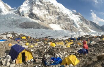
In this long journey, we acclimatize at Samagaon to adjust to the thin air as we are at a higher elevation. We will not stay idle but will explore this village of Buddhist culture. We will be noticing the lifestyles of the locals and experiencing their culture. Additionally, we have other explorations planned as well. The options include to hike to the Manaslu Base Camp or continue to Birendra Lake and then climb the ridge to Pungyen Monastery. This monastery is in the south of Samagaon which is about two and a half hours’ hike. It is hidden behind the ridge in front of Manaslu and gives us a tremendous view of the glaciers. Birendra Tal is a glacial lake at 3,450m where ice blocks tumble into the lake with thunder displays. Samagaon is indeed an interesting place for acclimatization
-
Day 11: Trek from Samagaun (3,530m/11,581 ft) to Samdo (3,875m/12,713 ft)
Trek Distance 8.2 km/ 5 miles
Highest Altitude 3,875m/12,713 ft
Trek Duration 3-4 hrs.
The trek today is comparatively more interesting and pleasant. We will be crossing the pasture areas and ascending to the valley. The trail leads us to forests with juniper and birch where we enjoy the beauty of nature. As we reach down the Budhi Gandaki river, we will be crossing the wooden bridge over it and climb up steeply across the river. We will be getting an amazing view of the mountains, especially Manaslu as we will be reaching Samdo, which is a Tibetan refugee village. Upon reaching Samdo, we will also explore the village and the surrounding hills
-
Day 12: Trek from Samdo (3,875m/12,713 ft) to Dharamsala (4,480m/14,698 ft)
Trek Distance 11.7 km / 7.2 miles
Highest Altitude 4,480m/14,698 ft
Trek Duration 3-4 hrs.
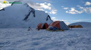
With an exciting day ahead, we walk down the edge through fields and old mani walls, crossing the wooden bridge over the BudhiGanadaki river. We begin walking upward of the valley. We will be noticing the mani walls and the prayer flags hung on the route, signifying the closeness of the Larkya La Pass. After crossing two streams, we will witness the Larkya Glacier which is unquestionably magnificent. As we enjoy the view, we further trek around the valley of SalkhaKhola and climb up again reaching the stone guest house (4,450m). The stone guest house is not a lodge but it is a kind of shelter better known as Dharamsala or Larkya La Phedi. Today’s day would be a gratifying day as we will get an amazing view of the Larkya Glacier and the amazing view of Mt. Manaslu is a great angle. The short trek today gives us plenty of time later onwards to acclimatize and relax.
Overnight at “Dormitory /Tent”
-
Day 13: Trek from Dharamsala (4,480m/14,698 ft) to Bhimtang (3,720m/12,205ft) by crossing Larkya la Pass (5,160m/16,929ft)
Trek Distance 24.7 km/15.3 miles
Highest Altitude 5,160m/16,929ft
Trek Duration 7-8 hrs
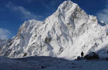
The exciting part of the journey awaits us, as we will be trekking around the Manaslu circuit crossing the Larkya La Pass (5,100m). After early morning breakfast, we will leave Dharamsala as it will be a whole day trek. The weather is the most important factor, it will decide if the trek becomes more challenging as strong winds and a storm could possibly occur. We being by crossing the moraine, descending down to a small lake. The trail begins to be rough and unclear as we have to cross the south of a steep grassy slope. Our route stays on the moraine to an edge which is marked by two landmarks. The prayer flags mark that the route is visible so that we can continue trekking. Carefully trekking, we will descend to four frozen lakes then finally climbing a steep trail to the pass. The four frozen lakes look undeniably striking. From the past, we get outstanding panoramic views of Himlung Himal, Cheo Himal, Kang Guru, and the great Annapurna II. As we live in the moment and admire the beauty of nature, the trail takes us to the top of the moraine, heading to the west and making steep, rough bends. We further cross the moraine then descend gently to another grassy moraine at 4,450m. As we have descended, the trail becomes easier to walk in, and then we reach a small meadow. The valley begins to widen as we near the large meadow, mani walls, and small houses that indicate we have reached Bhimthang.
-
Day14: Trek from Bhimtang (3,720m/12,205ft) to Gho (2,550 m/8,367 ft)
Trek Distance 10 km/ 6.2 miles
Highest Altitude 3,720m/12,205ft
Trek Duration 4-5hrs
After a Time of a challenging journey, the pursue begins to variegate to the crystal current and the promontory water of the Dudh Koshi river. We will be contradicting the wooden bridge then through a dense pine sylvan where we will get a sight of the blooming rhododendron flowers with a diversity of ensign. This is flower versed at a leap. A wide range of animals and birdwatch are seen in the sylvan as well such as sheep, horses, jackanapes, etc. We then trial a landslide making a precipice escalade onto an edge ornamented with prayer flags. Above the Marsyangdi bottom, we can see the culminate of the mountain, Lamjung. After a perambulate to the river bank, we will lastly arrive at Gho.
-
Day 15: Trek from Gho (2,550 m/8,367 ft) to Dharapani (1,910m/6,266ft)
Trek Distance 6 km/ 3.7 miles
Highest Altitude 2,550 m/8,367 ft
Trek Duration 3-4 hrs.
As we have been descendent, the imposition now is basically downhill. We will be trekking through many fields and pastures. We will remark that the beautiful prime rosebay is broadcast everywhere along with oak timber. Soon after, we arrive at Tilje which is an abundant Gurung settlement. This village is famous and well known for Brandy. After farewelling the wick via an insensibility arch, we will cross the Dudh Koshi anabranch following its embank and migration declivous through a scrub forest. While journey, the walls of the Marsyangdi valley emerge massive and we follow the course of the Annapurna circumambulate journey but in reverse. We will moderately be securement glance of the inn in Dharapani from a discrepancy. After the last difficulty of crossing the stiff overbridge, exceedingly the chortens, and another long stop overbridge, we will reach Dharapan.
-
Day 16: From Dharapani (1,910m/6,266ft) We’ll Drive to Besisahar (760 m/2,493 ft) - then drive back to Kathmandu.
Driving Hours 224km/139miles
Highest Altitude 1,910m/6,266ft)
Today we will be on the road the whole day. After early morning breakfast, we leave Dharapani to Besishar on a local jeep or a bus which will approximately take about six to seven hours. The drive will be scenic as we will pass many villages, Marsyangdi river, bhulbhule town, and Khudi. According to the schedule, we should be reaching Besisahar at least before 3 pm so that we can catch our Private Transport to Kathmandu. In case the time is not favorable to us, we will have to extend a day in the itinerary. After catching a bus that takes us back to Kathmandu, we will be getting the sight of the Marsyagdi river meeting the Trishuli river as we head west on the Prithivi Highway. The drive has many beautiful and natural scenery that pleases our eyes with terraced lands a last few glimpses of the peaks.
Include / Exclude
Accommodation Details During the Manaslu Circuit
Accommodation Details during the Manaslu Circuit itinerary includes fifteen nights lodge to lodge stay at a mountain where we use the best available lodge and select the best accommodation during the trekking. We provide seven nights room from the Sotikhola, Namrung, Lho, Samagaun(2N), Bhimtang, and Gho. eight nights standard room at Machha Khola, Doban, Philim, Deng, Ghap, Samdo, Dharamsala, and Dharapani.
Three nights Hotels in Kathmandu before and after the trek is included in the package. Hot showers, Wi-Fi will be available at an extra cost in possible places.
Best Time for Manaslu Circuit Trek
Best Time for Manaslu Circuit Trek is dependent on Weather and temperature factors for the best season of the Manaslu trek in Nepal. March to May, September to November is the most energetic season for Manaslu trek.
Heavy snowfall in the winter season from December until February closed the lodge at Dharamsala, makes it difficult to cross Larkya La Pass. From June to August is the rainy season. We do not recommend trekking in the winter and rainy seasons to anyone.
Cost Includes:
-
- Airport Pick-up and Drop Off.
- Licensed and trained trekking guides.
- Potters for carrying goods and supplies.
- Meal on full board (breakfast, lunch, dinner) basis during the trek
- 3 Nights Accommodation in the 3 Star Hotel in Kathmandu with B & B. (Bed & Breakfast)
- All accommodation during the trek.
- All meals and hot beverages during the trek.
- Transportation to and from trail head by Private Transport.
- All necessary documents and permits for trekking (where applicable)
- National Park/Conservation Area entry Permit, Insurance, and equipment for the staffs.
- Coordination of quick Rescue service (Costs covered by your Insurance Plan)
- Trekking staff’s wages & 1 hr. trekker massage after your trek
- Welcome dinner in a Nepali Cultural Dance restaurant in Kathmandu.
- Trekking Map, T-shirt, and Trekking certificate.
- Exclusive of Medical Kit Bag
- All Government and Local Taxes
- International Flight Ticket Re-Confirmation.
- Meals will be start when your trek starts.
- Trekking Staff Insurance of $10,000 Per Person.
Cost Excludes:
- International Airfares.
- Travel/Trekking Insurance.
- Excess baggage charges More than 16kg and hand bag more than 5 kg in domestic flights.
- Visa fees.
- Airport Departure Taxes.
- Drinks (Cold and Alcoholic) Rescue charge, Hot water, Shower, WiFi, Battery Charge etc.
- Tips for The staffs.
- Expenses of Personnel nature and Permit and Liaison officer fee (where Applicable.
- Meals during stay in the Kathmandu and Pokhara.
- Domestic Ticket of Lukla, Jomsom, Pokhara etc.
- Extra Hotel in Kathmandu and Pokhara.
Price per person
Usefull Information
The Manaslu Circuit Trek is a popular trekking route in Nepal, located in the Manaslu Conservation Area. Here is some additional information about the trek:
- Duration: The trek usually takes around 14 to 16 days to complete, depending on the itinerary and trekking pace. This includes both the ascent and descent, along with acclimatization days.
- Permits: To trek in the Manaslu region, you need two permits: the Manaslu Restricted Area Permit (RAP) and the Annapurna Conservation Area Permit (ACAP). These permits are obtained through registered trekking agencies and require a minimum of two trekkers in a group.
- Difficulty Level: The Manaslu Circuit Trek is considered a moderately difficult trek. It involves long and steep ascents, high altitude, and challenging terrain. Previous trekking experience and a good level of fitness are recommended.
- Altitude: The highest point of the trek is the Larkya La Pass at an altitude of 5,160 meters (16,930 feet). Proper acclimatization is crucial to avoid altitude sickness.
- Accommodation: Along the trekking route, there are teahouses and lodges available for accommodation. These basic guesthouses offer rooms and meals, providing a comfortable resting place for trekkers.
- Highlights: The trek offers stunning views of snow-capped peaks, including Mount Manaslu (8,163 meters), as well as surrounding peaks like Himlung Himal, Cheo Himal, and Ganesh Himal. The trail passes through beautiful landscapes, including lush forests, terraced fields, glacial valleys, and traditional mountain villages.
- Cultural Experience: The Manaslu region is home to diverse ethnic communities such as Gurungs, Tibetans, and Tamangs. Trekkers can experience their unique cultures, traditions, and hospitality during the trek.
- Best Time to Trek: The recommended trekking seasons for the Manaslu Circuit Trek are spring (March to May) and autumn (September to November). These months offer stable weather conditions, clear skies, and favorable temperatures for trekking.
Remember, it’s essential to plan your trek with a licensed trekking agency, hire experienced guides/porters, and ensure you have adequate travel insurance. Safety precautions and proper equipment are crucial for a successful and enjoyable trekking experience in the Manaslu region.
Equipment List
FAQs
-
 Best Seasons March to May, September to November
 -
 Group Size 2-20
 -
 Duration 16 DAYS BOOKING OPEN
 -
 Maximum Altitude 5550M
 -
 Trek Difficulty Challenging


Leave a Reply